
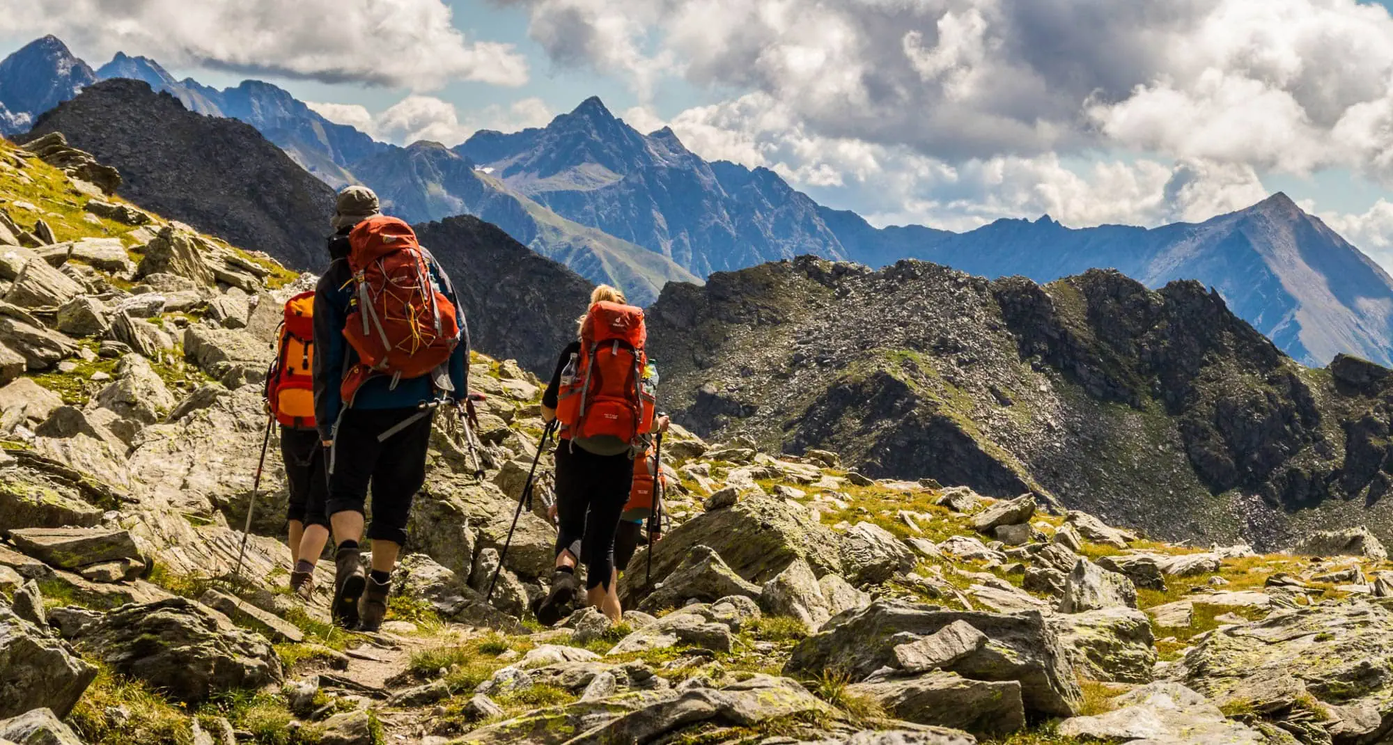
The E5 Alpine Crossing from Oberstdorf to Meran is the Alpine crossing that is meant when someone simply says „over the Alps“: six days of hiking, four mountain groups, three countries, about 100 kilometers on foot And at the end, a cappuccino under the palm trees. You start in the Allgäu at 813 meters, cross the Lechtal and the Ötztal Alps and climb to Niederjoch at 3,019 meters to descend into South Tyrol. The E5 hiking trail itself is much longer; it starts on the Brittany Atlantic coast and ends in Verona.[1]. But this particular section has become famous.
Famous also means full. The huts on the E5 are booked months in advance in July and August, the mountain schools send groups off every week, and on the Pitztal Jöchl you stand in a queue on beautiful days. Nevertheless, the journey is worth it if you approach it properly: book early, start during the week, take advantage of the weather window, and above all, walk lightly. Because the number that defines this tour is rarely mentioned in the brochure: about 6,500 meters of descent[2], Of which 1,900 on a single morning through the Zammer Loch.
I walked over the Alps twice, in 2014 and 2015. Munich to Venice Dream Way With just over ten kilograms on my back and 2017 from Vienna to Nice with 4.3 kg base weight including tent. I am familiar with the E5 from shorter tours, not as a whole, but rather as a destination in Meran in late summer 2017 after 800 kilometers from the east. Based on this experience and on what we learn about weight every day as backpack manufacturers, this guide has been built. It is the stepping stone of our pillar for hiking and camping. Alpine crossing on foot.
The E5 Alpine Crossing at a glance
Get the key figures ahead of time so you know what to expect:
| key figure | Value | Comment |
|---|---|---|
| Walking distance | ~104 km | Classic option with bus, taxi and lift to the usual locations. Those who want everything included will spend between 130 and 160 km.[2] |
| Metres gained | ~5,000 up, ~6,500 down | Degradation is the theme of this tour, see below |
| Stages | 6 | Plus return day. Sporty in 5, relaxed with a night in the Similaun hut in 7 |
| Highest point | 3,019 m | Niederjoch with the Similaun Hut, border between Tyrol and South Tyrol |
| Further passports | 4 | Mädelejoch 1,974 m, Seescharte 2,599 m, Wannejöchl ~2,500 m, Pitztaler Jöchl 2,996 m |
| Difficulty | One-bedroom flat to two-bedroom flat | Mountain hiking trail, individual sections with rope access, snowfields possible until July |
| Overnight stay | Cabins | Alpenverein huts plus the ski hut Zams and the private Similaun hut, all with half-board |
| Season | From mid-June to the end of September | Best window from mid-July to mid-September |
| Start and finish | Oberstdorf, Meran | Both with rail connection; return journey by bus 5 to 6 hours |
One point that often annoys newcomers: On the E5, you take buses, taxis and the cable car in between, and That is not cheating. The trails in the Lechtal Valley, the Pitztal Valley and the Ötztal Valley are paved; the mountain schools have been banning them since the 1970s, and the huts are accordingly timed. What you walk on are the passes, and they are quite steep. If you skip the transfers, you’ll spend two days on the road and gain nothing except blisters.
One more detail for the details: The official E5 route leaves the Ötztal valley over the Timmelsjoch into the Passeiertal and reaches Meran via Hirzer[3]. The route via Vent, the Martin-Busch Hut and Niederjoch is the variant that the mountain schools have established and that almost everyone follows today. It is higher, more spectacular and one day shorter. This guide is about this classic variant.
The 6 stages from Oberstdorf to Meran
The route layout follows the rhythm of the huts. There are hardly any alternatives in between, so the chain at the bottom is identical for almost all groups and self-guided hikes. The map shows the walking distance in copper, the transfers in dotted lines, and the original route over Timmelsjoch in gray.
Route and elevation profile of the E5 Alpine Crossing: Walking distance in copper with the six stages, transfers by bus, taxi and lift marked in gray, the original route over the Timmelsjoch in gray dotted. Elevation profile from the terrain model along the OSM track; x-axis are kilometers walked; the data shown in the table. Track: © OpenStreetMap contributors · Relief: Mapzen/AWS Terrain Tiles · Watercourses: © OpenStreetMap contributors.
| Stage | Walking time | Numbers and Character |
|---|---|---|
| 1st Oberstdorf → Kemptner Hütte | ~3 h (from Spielmannsau) | ~6 km, ~870 hm uphill. Through the Sperrbach valley, short start. From the Oberstdorf train station it is 13 km and 5 hours on foot. |
| 2nd Kemptner Hut → Memminger Hut | Around 6 hours | ~14.5 km, ~1.030 hm up, ~990 hm down. Over the Mädelejoch (1,974 m) to Holzgau, taxi to Madau, then 800 hm up to the Memminger Hütte. |
| 3rd Memminger Hut → Zams | 6 to 7 hours | ~13.5 km, ~490 hm uphill, ~1.900 hm downhill. See saddle (2,599 m), then Zammer Loch to the Inn valley at 767 m. |
| 4. Zams → Braunschweiger Hütte | 7 to 8 hours | ~15 km, ~1,400 hm uphill, ~1,400 hm downhill. Lift to Krahberg, Glanderspitze (2,512 m), descent to Wenns, bus to Mittelberg, 1,000 hm up to Braunschweiger Hütte (2,759 m). |
| 5. Braunschweiger Hütte → Martin-Busch-Hütte | 7 to 8 hours | ~20 km, ~1,000 hm uphill, ~1,350 hm downhill. Pitztaler Jöchl (2,996 m), descent to Rettenbachferner, bus from Sölden to Vent, ascent to Martin-Busch-Hütte (2,501 m). |
| 6. Martin-Busch Hut → Meran | 4 to 5 hours | ~10 km, ~520 hm uphill, ~1.320 hm downhill. Niederjoch and Similaunhütte (3,019 m), descent to Vernagt, bus through the Schnalstal to Meran (325 m). |
The values are rounded and compared with the daily schedules of the Alpinschule Oberstdorf, the DAV Summit Club and the Oberstdorf Tourism Association. Depending on the starting point, the variation on the Rettenbachjoch and the descent route, they fluctuate by a few hundred meters in height. What remains unchanged: Four out of six days end at altitudes of over 2,200 meters.
Stage 1: Sperbach Valley and Kemptner Hut
The first day is short, and that’s a good thing. The line bus from Oberstdorf will take you to Spielmannsau, from there the path leads through the Sperrbachtobel, a narrow gorge with wooden bridges and some wire ropes, before the valley widens and the Kemptner Hut appears at 1,846 meters. 290 beds, since 1891 at this location, no mobile network, no power outlet in the room. The hut explicitly states on its website that it is a refuge for hikers and not a hotel, and that is exactly how it feels.
Stage 2: Mädelejoch, Lechtal and Memminger Hütte
Shortly after the hut lies the Mädelejoch, with 1,974 meters the lowest crossing of the tour and at the same time the border to Austria. Then it goes 900 meters down to Holzgau in the Lechtal valley. From here most people take the line taxi over the Bach to Madau to the parking lot of the Memminger Hut, which saves 14 kilometers of asphalt. The ascent from there is the real day: 800 meters of elevation gain through the Madautal to the Memminger Hut at 2,242 meters, with 145 sleeping places the meeting point of the Lechtal Alps and the hut that fills up fastest.
Stage 3: Seescharte and Zammer Loch
The day everyone is talking about. First, 350 meters up to the summit ridge at 2,599 meters, a narrow section with up to 10 inches of snow on its northern side until July. Then begins the longest descent of the tour: 1,900 meters of elevation gain through the Zammer Loch, From the Oberlochalm and the managed Unterlochalm, past Zams in the Inn Valley. The valley is beautiful and the knees still hurt at the end. You can stay in the valley or, if you still have the strength, at the Zams ski hut at Venet at 1,780 meters.
For 2026, there are two changes here: Due to a highway construction site, the descent ends via a newly marked path at the gravel works; from there, a shuttle costs 2 euros to the center and to the Rifenalbahn. And The Venetbahn itself is being rebuilt, From summer 2027, the Rifenal and Weinbergbahn chairlifts will take over the ascent.[4].
Stage 4: Venet, Pitztal and Braunschweiger Hütte
By train, you can head up to Krahberg (2,208 m), 2026 with the replacement chairlifts and a little more on foot, then over the ridge to Glanderspitze (2,512 m) and down to Wannejöchl to Larcher Alm and Wenns in the Pitztal valley. A day of panoramic views of the Lechtal in the north and the Ötztal glaciers in the south.
You are currently viewing placeholder content from Instagram. To access the actual content, click the button below. Please note that doing so will share data with third-party providers.
Further InformationFrom Wenns, the bus takes about an hour to reach Mittelberg in the valley, and then comes the second part, which many underestimate: 1,000 meters of elevation gain up the Pitztaler Glacier stream waterfall to the Braunschweiger Hut at 2,759 meters. With Mittelbergferner and Wildspitze just outside the door, this is the most spectacular hut of the tour.
You are currently viewing placeholder content from Instagram. To access the actual content, click the button below. Please note that doing so will share data with third-party providers.
Further InformationStage 5: Pitztaler Jöchl and Vent
From the hut you have two options for the route: the Pitztal Jöchl (2,996 m) with a rocky, rope-secured trail or the Rettenbachjoch (2,990 m) with a narrow, exposed ascent over snow. With fresh snow and poor visibility, the Jöchl is the safer choice; with firm snow, the climb is faster. Ask the mountain team in the evening, You know the terrain better than any app. Down below, the ski world at Rettenbachferner awaits with lifts, a restaurant, and a bus stop. From there, you drive via Sölden to Vent at 1,896 meters and climb the valley for another two hours to the Martin-Busch-Hütte.
You are currently viewing placeholder content from Instagram. To access the actual content, click the button below. Please note that doing so will share data with third-party providers.
Further InformationStage 6: Niederjoch, Similaun Hut and Meran
The final day begins with 520 meters of elevation gain through scree and over the remains of the Niederjochferner; only remnants of the glacier and snowfields remain above. the Similaun Hut directly on the Niederjoch, 3,019 meters, From the border with Italy, and anyone who has an hour left can still walk over the block granite to the Ötzi discovery site at Tisenjoch at 3,210 meters. Then 1,320 meters down to Vernagt at the dam lake and by bus line 261 through the Schnalstal to Naturns and Meran. In the morning, I was standing on the loose gravel; in the evening, palm trees on the Passer. In 2017, my journey from the other direction was similar: After the Dolomites and Bolzano, Meran was the first city where the heat in the valley was worse than any ascent.
You are currently viewing placeholder content from Instagram. To access the actual content, click the button below. Please note that doing so will share data with third-party providers.
Further InformationHutments on the E5: Prices for 2026 and booking
The huts are the bottleneck of this tour; more than the route and more than your fitness level. Before you plan anything else, secure the chain from Kemptner to Similaun hut. The prices below are as of 2026 and are from the hut sites; they are for adults without Alpenverein membership.
| Hütte | Height | Prices and booking |
|---|---|---|
| Kemptner Hütte (DAV Allgäu-Kempten) | 1,846 m | 290 places. Camp 20 €, bed 26 €, members 10 and 14 €. Book via Huetten-Holiday, season 4 June to 4 October 2026, cash only[5]. |
| Memminger Hütte (DAV Memmingen) | 2,242 m | 145 places. Camp 26 €, Dormitory 36 €, Members 15 to 24 €. Half-board with buffet breakfast 46 € extra. Huetten-Holiday[6]. |
| Ski hut Zams (private) | 1,780 m | E5 half-board from €56. Alternatively, guest houses and hotels below in Zams. |
| Braunschweig Hut (DAV Braunschweig) | 2,759 m | Mattress storage 31 €, room storage 36 €, members 17 and 23 €. Breakfast buffet 19.40 €, dinner à la carte, cash only. |
| Martin-Busch Hut (DAV Berlin) | 2,501 m | 114 places in beds and camps, half-board 28 € plus overnight stay. Reservations through the landlord (Hotel Vent). Season 9 June to 20 September 2026. |
| Similaun Hut (private) | 3,019 m | Only with half-board: camp €87, room €95. Deposit €45 per person per night, non-refundable. By mail until early June, thereafter only by phone. Season starting June 13, 2026, cash only.[7]. |
The booking windows open early. If you want to go in July or August, should book in January to March, Because the Memminger and Braunschweiger huts are often already fully booked in April for the high season. The Alpine Club huts operate via Huetten-Holiday or the reservation system of the Alpine Clubs, with deposit and cancellation deadlines. The Similaun hut operates according to its own rules: Mail by the beginning of June, then by phone, and The deposit is gone if you cancel at short notice. If you cancel three weeks in advance, she will credit you the amount for the following year.
Membership in the Alpine Club is required for this tour. At the four club huts you save between 10 and 14 euros per night, plus the insurance coverage, which makes the difference between 0 and several thousand euros on a helicopter flight over the Pitztal Jöchl. At the Kemptner hut you can even join in in the evening. Those who are familiar with the booking logic of the Tour du Mont Blanc Those who know it will feel at home here: the same early booking panic, smaller huts, but in a language.
How difficult is the E5 Alpine Crossing?
Technically, the E5 is a Mountain hiking trail from steps T2 to T3. There is no climbing wall or glacier on which you would need crampons, but there are four places where safety and fearlessness are non-negotiable: the wire ropes in the Sperrbach valley, the narrow sea cliff with possible old snow on the north side, the rope-secured climb on the Pitztal Jöchl, or the exposed ascent to the Rettenbachjoch, and the block area with snow fields on the Niederjoch. In fog or new snow, any of these places becomes a reason for a rest day.
Conditionally, the tour is tougher than its reputation suggests. Four days in a row with 1,000 to 1,400 meters of elevation gain and walking times of six to eight hours, plus the altitude: Three nights at over 2,200 meters, one at 2,759 meters, and optionally one at 3,019 meters. Those who come from the flatlands sleep poorly in the Braunschweiger Hut and head out the next morning with a headache. That’s normal and no cause for concern, but it’s a reason to keep the backpack small.
That's exactly where the difference lies compared to a round like the Stubaier Höhenweg, where you stay at the top and the altitude meters are distributed evenly. The E5 falls into the valley three times: to Holzgau, then to Zams and then to Vernagt. The Zammer Loch alone has a descent of 1,900 meters, and that is after climbing up to the Seescharte. Anyone who travels here with ten kilos and rigid boots will suffer knee pain in Zams and carry them all the way to Meran.
The best time for the E5
The huts open from early to mid-June depending on the snow conditions and close from mid-September to the end of September, with the Similaun Hut opening on June 13, 2026. Within this window: From mid-July to mid-September The passes are most reliable without snow and the weather conditions are most stable. In early July, there may still be fresh snow on the Seescharte and Niederjoch; then Grödel is a good idea. From mid-September onwards, the days are shorter; at over 3,000 meters, it freezes at night, and a winter break is then always possible.
The best weather is the crowds. From mid-July to the end of August, the huts are packed; the paths between Memminger Hut and Zams and around the Pitztal Jöchl are like a procession on beautiful days. The first half of September Therefore, for many it is the best compromise: stable autumn weather, clear visibility, fewer people, huts still open. And no matter when: thunderstorms almost daily in late summer in the afternoon, so get out early and over the pass in the early afternoon. If you arrive in Merano in August, plan for the afternoon in the shade; the tips from our guide to Merano Hiking in hot weather apply literally in the Etschtal.
How much does the E5 Alpine Crossing cost?
Organized hiking costs significantly less than guided tours, but more than many would expect, because the Similaun hut and half-board are expensive. Here is an example calculation for a person without an Alpine Club membership, with half-board at all the huts and the usual transfers:
| Post office | Amount | What's inside |
|---|---|---|
| 5 hut nights with half board | ~330 € | Kemptner ~60, Memminger 72, Zams 56, Braunschweiger ~70, Martin-Busch ~50 (overnight stay plus half-board or breakfast and dinner) |
| Night in Meran | ~35 to 80 € | Youth hostel or simple hotel, because the return bus leaves in the morning |
| Transfers on the way | ~50 € | Bus Spielmannsau, taxi Holzgau to Madau (~11 to 15 €), lift Zams, shuttle 2 €, bus Wenns to Mittelberg (~5 €), buses Rettenbachferner to Vent and Vernagt to Meran |
| Drinks, lunch, snacks | ~120 € | Six days at €20 each, including hut prices for cyclists and cake |
| Return journey from Meran to Oberstdorf | from 49 € | Shuttle bus (Prenner, Schmid), 5 to 6 hours. Trains also run, with three transfers and the last meaningful train at 15:16. |
| Arriving in Oberstdorf | 30 to 80 € | Train, depending on the starting point and the discount price |
| Sum | ~620 to 730 € | As an Alpine Club member, you save around €50 at the mountain huts |
For comparison: The classic week of guided hiking at the Alpinschule Oberstdorf costs 2026 euros for Alpine Club members and 1,219 euros for others, including a mountain guide, half-board, transfers, a return bus and a backpack transport on three days. The extra cost of around 500 euros buys you mainly one thing: the mountain range you don't have to take care of yourself, Plus someone who assesses the conditions at the Pitztaler Jöchl. For the first multi-day hike in the high Alps, this is a fair deal. For anyone who has ever hiked from hut to hut for a week or more, it’s money well spent on things they can do themselves.
Camping on the E5: the honest answer
No. In Tyrol, the Camping Act has banned camping outside of camping sites since 2001; the fine is 220 euros.[8]. In South Tyrol, as in the whole of Italy, there is a ban with fines between 100 and 500 euros, and the descent from the Niederjoch leads through the Texelgruppe Nature Park, where the protection area regulations come into effect. In the Bavarian part, the legal situation is more relaxed, but the only Bavarian section ends after a day at the Kemptner Hut. A makeshift bivouac above the tree line is tolerated if there really is one. A planned tent next to the Braunschweiger Hut is not one.
At Vienna-Nice 2017 we had the tent with us for 107 days and slept in it for about 15 nights, always in the places where there was no shelter within reach. On the E5 I would leave it at home. The campsites are all located in the valley (Oberstdorf, Holzgau, Zams, Sölden), that is exactly where you are not in the evening. The E5 is a hut tour, and it is the easiest to do as a hut tour.No tent, no sleeping bag, no stove, no sleeping mat. That saves more weight than any equipment optimization could ever bring.
Pack list E5: under three kilograms base weight over the Alps
This is the part where we as manufacturers have the most say, and the list here is intentionally short. It follows the same logic as ours. Mountain hut tour packing list, With two differences: At 3,000 meters you need more insulation while on a mountain tour, and The descents require poles. Anyone who wants to read about the basic questions regarding the tent or the tent and the total weight can find them in the Alpine crossing packing list. Clothing, shoes and poles that are worn are not included below.
| Item | Weight | Manufacturer's comment |
|---|---|---|
| WeitLäufer Agilist (2026) | 570g | For a hiking tour on 30 liters rolled up. It Ultra 200X is waterproof, most of the seams are taped, the rain cover stays at home. |
| Rain jacket | approx 180 g | In August, it can rain at Pitztal Jöchl. Lightweight models in the Waterproof jacket buying guide. |
| Rain trousers | ~120g | On the long descents during weather changes, they are more valuable than any second pair of pants. |
| Insulation jacket (down or synthetic) | ~250g | Overnights at 2,759 and 3,019 meters, breakfast in the Similaun hut at 3 degrees in the dining room. |
| Merino shirt for changing, 2 pairs of socks | ~240g | Laundry can be done at each cabin by the well; it usually dries overnight as well. |
| Cap, thin gloves, scarf | ~110 g | Early start at Niederjoch: Tires on the loose gravel, fingers are stiff. |
| Hut sleeping bag made of silk | ~110 g | Mandatory on all Alpine Club huts. |
| Microfiber towel, earplugs | ~45 g | The earplugs are the most important piece of equipment at the Memminger Hut. |
| Sunglasses, sunscreen cream LSF 50, lip protection | ~120g | Four days at an altitude of over 2,500 meters, sometimes on snow. |
| First aid, blister plasters, hygiene | ~230g | Blister generously filled, the rest is filled to travel size. |
| Headlamp | ~28g | For the way to the toilet in the camp and early starts. |
| Power bank 10,000 mAh, cable | ~195 g | There are no power sockets at the Kemptner Hut, and there are few elsewhere. |
| 2 bottles of 1 l each (empty) | ~70 g | There is water at every hut and alpine pasture; 1.5 liters is enough between two stations. |
| ID, cash, card or app | 150g | Almost all huts only accept cash; plan to bring 400 euros in bills. |
| Grödel (optional, June and September) | ~250g | Only reported old snow at Seescharte and Niederjoch. Leave at home in the high summer. |
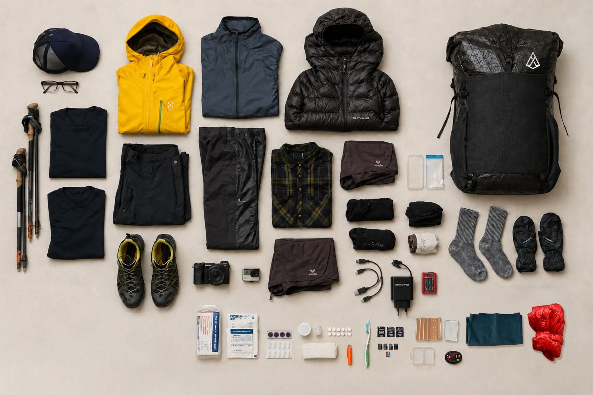
Without a backpack, the base weight is around 2.4 kilograms. In addition, you will be carrying water and food with you in the morning; you won't be carrying much else on this tour:
| Post office | Weight |
|---|---|
| Base weight (table above, without the lug) | ~2.450 g |
| Water 1.5 l | 1.5 kg |
| Supplies for the day | ~400 g |
| TOTAL WEIGHT | ~4.350 g |
Four and a half kilos. That’s less than the 8 to 10 kilograms that most E5 guides cite as the upper limit, and that’s the reason you don’t need the backpacks of the mountain schools. On my first Alpine crossing in 2014, my backpack weighed just under ten kilograms without a sleeping system, and I still remember how every descent felt. In 2017 it was 4.3 kilograms with a tent.
Regarding the volume issue: For this setup, a 25- to 30-liter backpack is sufficient. It Agilist's large at 54 liters, but with the Rolltop it adapts to the contents, and at 570 grams it weighs less than most daypacks. Those who prefer a smaller backpack will find the criteria in the product description. Guide to the small daypack. And about the shoes: They work on the well-maintained paths of the E5. Trailrunner with grippy sole Very good if you are used to them. An ankle-high boot protects you from slipping less than you might think, and costs less energy downhill. For deep snow, the crampons are more important than the boot.
Arrival, return journey and map
Oberstdorf has a central train station with direct trains from Munich and Ulm; getting there is therefore the easy part. The bus to Spielmannsau leaves in front of the station. Meran has rail connections to Bolzano, and from Bolzano you get to Innsbruck via the Brenner and on to Kempten, but that takes all day with transfers, and the last meaningful train from Meran leaves at around 3 PM on weekdays. That’s why almost everyone takes the bus. return by shuttle bus to OberstdorfPrenner and Schmid travel every day during the season, for five to six hours of travel at a cost of 49 euros. Book the bus together with the huts; in August it is also fully booked.
For orientation, you can use the Alpine Club map or a good app with offline maps; the route is consistently marked as E5. Nevertheless: In the Seescharte and at Niederjoch, the markings disappear under fresh snow; then a track on your phone is more helpful than any map. For the Tyrolean stages, e5.tirolwest.at lists the timetables of the Lechtaler Linientaxis, the bus from Wenns to Mittelberg, and the Ötztaler lines. The timetables change annually., Check it two weeks before the start.
Frequently asked questions about the E5 Alpine Crossing
Approximately 104 kilometers on foot in 6 stages, With an ascent of about 5,000 meters and a descent of 6,500 meters, you’ll be hiking between four places on foot. There are also bus, taxi, or lift options between the hiking routes. Those who want to do everything will cover between 130 and 160 kilometers.
Six days plus one day for the return journey, That is seven to eight days. Anyone who stays at the Similaun Hut or takes the Ötzi discovery site with them plans to spend an extra day.
Mountain hiking trail T2 to T3 with rope-secured sections on Sperrbachtobel and Pitztaler Jöchl, Altschnee on Seescharte and Niederjoch until July. Conditionally, you need four days in a row with 1,000 to 1,400 meters of ascent and up to 1,900 meters of descent.
Yes. The trail is consistently marked and the huts are located at regular intervals. Advance booking of huts is required, stable weather conditions at the crossings, and experience with multi-day hikes in the mountains are prerequisites. In case of deep snow or little experience, a mountain school is advisable.
Mid-July to mid-September. The huts open from early to mid-June depending on the snow conditions and close from mid-September to late September. The first half of September is usually the best compromise between stable weather and less crowding.
For July and August between January and March. Memminger and Braunschweiger Hütte are often fully booked in April during the high season. The Similaun Hütte requires a deposit of 45 euros per night and accepts emails until early June, after that only phone calls.
Self-organized with half-board, transfers and return bus around 620 to 730 euros per person, As an Alpine Club member, you can save about 50 euros. Guided tours cost from about 1,200 euros starting in 2026.
No. In Tyrol, camping outside of campsites is prohibited and costs 220 euros in fines; in South Tyrol, it costs 100 to 500 euros. There are no campsites in the valley. The E5 is planned as a hiking tour and is the easiest hiking tour.
Next step
If you’ve read this far, you know what the E5 is all about: with six camping beds, a stable weather window and a backpack that doesn't hurt when you're hiking down the mountain. The first two you’ll complete in January at your desk. The third starts with the question of what you really want to carry at 3,000 meters, and the answer is almost always: less than the last time.
Sources
- Course and history of the European Long Distance Path E5 (Pointe du Raz to Verona, since 1972). de.wikipedia.org
- Key figures for the crossing of the Alps from Oberstdorf to Meran: 104 km, 4,950 hm ascent, 6,470 hm descent, Tourism Association TirolWest. e5.tirolwest.at
- The original route of the E5 from Zwieselstein and Timmelsjoch to Meran, Alpenverein Regensburg. alpenverein-regensburg.de
- Relocation at Zams, shuttle and replacement lifts during the renovation of the Venetbahn in 2026, TirolWest. e5.tirolwest.at
- Kemptner Hütte, rooms and camping, prices and booking window 2026. kemptner-huette.de
- Memminger Hütte, accommodation rates for 2026 and half-board. memmingerhuette.at
- Similaunhütte, prices and information 2026 (half-board, deposit, season). similaunhuette.com
- Camping in the mountains: Legal situation in Tyrol (Camping Act, 220 euros) and South Tyrol, Bergwelten. bergwelten.com